 Colpo di pedale cycling tours
SAMPEYRE – CROCE CIAMPAGNA - CASTELDELFINO
km 27
Route: mixed (asphalt and dirt)
Gradients:1.050 m.
Difficulty level: average
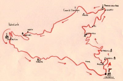
Starting from Cachesio, hamlet located at approximately 1 km upstream of Sampeyre, you
immediately take the aphalt road that passes in the built-up area alongside a small church and goes slightly uphill to the villages of Villaretto (1.085 m) after 1.5 km and Roccia.
It goes to the right toward Foresto and do not follow the detour to Villar, you reach the village after a series of steep bends, in the built-up area, go straight along the scenic asphalt road,
after 5.2 km the road becomes a dirt road and the slope decreases near Borgata Campanesio (1.518 meters).
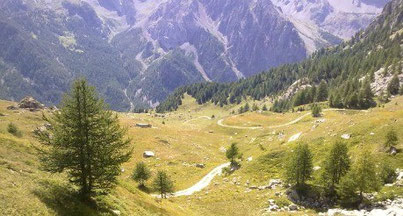
Continue up ignoring the GTA fork to the left and it through wide meadows and the villages Pui, Colletto di Mezzo e Colletto di Sopra, shortly after you ignore the junction for Colle di Luca and passing a bar which indicates a prohibition of passage for vehicles you continue in the plain and then slightly downhill until you see the indication on the right Croce di Ciampagna e Sentiero Alevé, then go up pushing the bike except for some stretch good for cycling until to cross the ridge near the Croce di Ciampagna (1.994 meters).
Descent and enter in the Alevè forest, after a first stretch you ignore the right fork to the lake Bagnour and continue along the main path in a technical descent with some flowing stretchs and reach the wide prairies upstream of Borgata Bertines (1.395 meters).

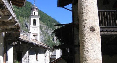
Among the houses you can see the path that descends to Casteldelfino where you can opt for the forest trail along the river bank of the Varaita torrent up to hamlet Torrette, where you connect to the main road and follow it up to Calchesio.


Copyright © colpodipedale.it