 Colpo di pedale cycling tours
PONTECHIANALE – PASSO DELLA LOSETTA – RIFUGIO VALLANTA
km 24
Route: mixed (asphalt and dirt)
Gradients: 1.300 m
Difficulty level: difficult
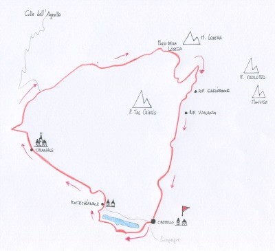
It leaves from the village of Castello and going out on the left you pass the artificial barrage of the dam and take the path that climbs the left bank of the reservoir. A Maddalena of Pontechianale near a camping you must take the asphalt carriage road that crosses the village and follow toward Chianale, after this village begin the bends of the Colle dell'Agnello, really hard climbing.
To the third bend (2.007 meters) near the Grange Rio leaves the asphalt and take the U18 GTA dirt road that runs through the Vallone di Sustra, crossing large grassland and reached Grange Pra
Verde (2.209 mt) the route becomes more challenging and sometimes it is necessary to push the bike on foot, where the terrain is more rocky and the slope increases.
Arrived to Passo della Losetta (2.872 mt) towards the Vallone di Vallanta you meet a
small military barracks and a junction where you ignore the left fork for Passo di Vallanta.
After a few steep switchbacks you reach a large plateau (2.561 m), it doesn't take the descent to the rifugio Vallanta and go instead to the left along the grassy line reaching Rifugio
Gagliardone and shortly after Rifugio Vallanta (2.450 m), from there begins a fast single-track following the GTA U9 downstream to Castello.


Copyright © colpodipedale.it