 Colpo di pedale cycling tours
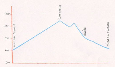
VILLAR SAN COSTANZO – COLLE DELLA LIRETTA

km 14 - Gradients: 600 m
Route: mixed (asphalt and dirt)
Difficulty level: average
Starting from the square of the town hall of Villar San Costanzo and take via
Pramarchetti and then on the right via Foresti (pillar) through the steep climb, after 2 km turn right toward Liretta, the road starts with asphalt and then becomes dirt.
After a series of switchbacks, follow the signs to the Colle and near a next fork (aqueduct, picnic area 4.8 km) continues to rise, near to the peak it reached the military road that climbs
towards the Sanctuary of Valmala, you descend for around few tens of meters and take to the right, along a path in the birches that ends on the panoramic hill Colle della Liretta (1.105
mt).
Descent in the direction of Busca and after a few hundred meters you get on the right
near a birch forest while ignoring the most obvious track that descends on the south, single-track that runs along the crest and at times crosses the military road, to the 9.5 km near a wide
glade the bottom becomes asphalt you turn right through the forest up to glimpse Borgata Rivoira Inferiore.
You pass a group of houses, and reached the next junction for Rivoira Superiore continue downhill but only until the first hairpin bend to the left, where you proceed straight ahead, taking the
dirt road that soon leads to Villar San Costanzo.


Copyright © colpodipedale.it