 Colpo di pedale cycling tours
FROM MONVISO TO THE SEA

6 days
Total length: 290 km
Total gradients: 9.000 mt
Number stages: 6
Difficulty level: difficult
Daily hours on the bike: 5-7
Period: from the end of June to mid september
From Monviso to the sea is a raid on mountain bike which involves the crossing of six
valleys cuneesi, Valle Po, Varaita, Maira, Vermenagna Tanaro and Stura, to reach the sea near Arma di Taggia.
Through one of the ancient network of salt roads between Piedmont, Liguria and France which were used primarily for the transport of oil, salt and other staples the bikers will pedal on the old
military roads that towards the end of 1850 put in communication the military fortifications built as a line of defense against French invasion, all surrounded by nature and magnificent
mountains.
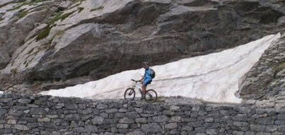
A route for trained bikers, 300 km in 6 days (total gradients: approximately 8.600 m), with hard climbs over 2.000 meters alternating with fantastic singletrack descents up to 0 meters of the
Mediterranean Sea.
First stage:
km 80
Gradients: 2.600 meters
Point of departure: Pian della Regina
Arrival location: Santuario di Valmala
First stage really hard, starting from Pian della Regina in the Po Valley to reach the Sanctuary of Valmala in Valle Varaita.
The Po valley is dominated by the imposing stone structure of Monte Viso that wich his 3.841 meters is the highest point of the Cozie Alps, for his height and location is a point visible from
great distances, in the grassy hollow of Pian del Re, surrounded by the peaks of the Monviso group, there is the source of the Po, the longest river in Italy, with his 653 km in length.
The extraordinary variety of environments of these two valleys with magnificent lakes, forests of stone pines, wonderful scenery that surrounding the bikers making less hard this first
stage.
The bikers will pedal in Valle Varaita of a dense network of paths and ancient mule tracks that cross the extensive high-altitude pastures, forest heritage is very rich with lush vegetation,
chestnut and woods like that “bosco dell'Alevé” that is the largest stone pine in the Alps.
In this valley are numerous examples of religious and medieval art, in a small side valley of Valmala rises the Sanctuary of Valmala (1,380 m), this construction was completed in 1851, this is
the place of arrival of this first long day.
Second stage:
Km 50
Gradients: 1.800 meters
Point of departure: Santuario di Valmala
Arrival location: Demonte
From the sanctuary of Valmala is the departure of this second stage that will cross the Valle Maira and Grana Valley to arrive in the town of Demonte in Valle Stura.
The landscape of the Valle Maira is particularly wild, a narrow and deep valley (with its side valleys and mountains over 3.000 meters as the Pelo d'Elva, Chersogno and the Brec de Chambeyron)
that the last century has inherited a dense network of trails, mule tracks and military roads that once connected the many villages with traditional stone houses, the features round columns and
the stone roofs.
Architectural-level include numerous rural chapels of Romanesque or Gothic origin that preserves frescoes and paintings, the Elva parish dating back to the 14th century and the Church of San
Costanzo al Monte (7th century).
The Valle Grana is the shortest of the South-West Alpine sector, is wedged between the Stura and Maira Valleys, his muletracks for centuries have allowed the connections between the many
scattered villages and the neighboring valleys.
Through two passes, Colle d’Esischie and Colle Fauniera, with a carriageable of military origin the high Valle Grana connects the nearby Maira Valleys and Stura.
You get to Demonte, the main centre of Stura Valley with the ancient road with its characteristic arcades and some 17th-century buildings, this valley was historically a place of passage of
people, shepherds and pilgrims in transit between the French and Italian sides.
Third stage:
km 50
Gradients: 1.600 meters
Point of departure: Demonte
Arrival location: Limone Piemonte
The third stage starts from Demonte in Stura Valley, this valley is the line which divides the Cozie Alps to the North with its steep valleys and the Maritime Alps to the South with its rugged
limestone slopes.
This itinerary arrives at Limone Piemonte in the Valley Vermenagna passing through the Valle Gesso climbing the Col dell'Arpione (1.761 mt) and the deep valley of Desertetto to reach
Valdieri.
Small village whose origins are late medieval, famous for its thermal baths and the main center of Valle Gesso. The only hill that allows to bypass the Valle Gesso throated of Roaschia is the
Colla delle Goderie leading to Vernante in Vermenagna Valley, in this part of the itinerary views of the mountains and on the surrounding valleys are exceptional.
The arrival of this third hard day is placed in Limone Piemonte, in the Middle Ages became a stopping place of the caravan that accompanying persons and transporting goods between Piedmont,
Liguria coast and Provence.

Fourth stage:
km 35
Gradients: 1.300 mt
Point of departure: Limone Piemonte
Arrival location: Colle dei Signori
From Limone Piemonte, follow the path towards the Colle di Tenda passing near to the ruins of the Central Fort and barracks, this route offers many beautiful sights on the Alta Valle Vermenagna
and Roya Valley.
The military road of the Colle di Tenda allows to see the series of fortifications that constituted the complex defensive system built between 1881 and 1895 on the French-Italian border.
Along this road past the strong military scenario will change by passing to a lunar landscape and desert due to erosion that in thousands of years have shaped the rocks in innumerable forms and
created Sinkholes and caverns.
The soil conditions of the military road to get to Colle dei Signori is torturous, not much sliding and sometimes very disjointed and this makes it hard this track with its ups and downs at high
altitudes, just before reaching the point of arrival will cross a broad endorsement of black earth crossed by whitish rocks, place of refuge for numerous marmots that live in these
mountains.
The Colle dei Signori where ends this fourth stage is the watershed between the Roya Valley and the Valley of Carnino which flows in Tanaro Valley.
Fifth stage:
km 44
Gradients: 1.246 mt
Point of departure: Colle dei Signori
Arrival location: Colla Melosa
From Colle dei Signori on a stony and disjointed ground follow the long path between valleys and rocky ridges is the watershed between the valleys of Roya and Tanaro, the passage through the
secular Woods of Navette composed predominantly by larch and white spruce is one of the best moments of this fifth stage, the path in the Woods is also known like the robbers road and offers
beautiful panoramic views.
Out of the woods a slightly ascent brings in the wide green valley from the gentle slopes at the foot of Monte Saccarello, the scenery changes again to get to the Passo di Collardente with a
rough and rocky environment, typical of high altitude scenery.
Continuing the itinerary from the French side get the Baisse de Sanson (1.707 mt) in a cool and shady pine forest, continue on the military road that is maintained at high altitudes through the
ruins of six barracks of Marta, the road climbs slightly and reached the maximum altitude of 1.960 meters, from here begins the descend passing near the Grai refuge from where you can admire the
rocky mass of the mountain Pratavecchia.
The road continues to descend to the bottom of the Valley in the direction of the impound, the environment returns rough and rocky until you reach the Colla Melosa (1.540
mt).
Sixth stage:
km 30
Gradients: 400 mt
Point of departure: Colla Melosa
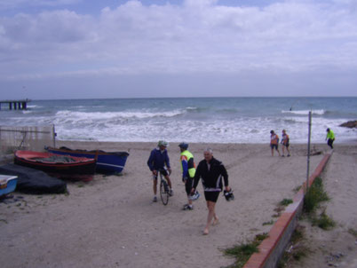
Arrival location: Ventimiglia
From Colla Melosa (1.540 mt) go down to Colla Langan (1.127 mt), a gentle slope that passes near the Tenarda Lake, a man-made reservoir situated in a picturesque location, coming down with ample
rounds between chestnut woods and olive groves bikers arrive in Pigna, characteristic town that takes its name from the pinecone structure of the medieval village, before reaching Ventimiglia
Liguria sea.
Type of bike recommended: the tour is accessible with any type of mountain bike of good level that
provides at least the front suspension. However, we recommend a bike full-suspended with suspensions 100-120 mm.
The return trip from Ventimiglia to Limone is by train and bus from here to Crissolo.
For the duration of the tour will be accompanied by qualified guides, mechanical assistance and logistical support is provided by the guides themselves, supported by off-road vehicle that
followed the bikers throughout the tour (with the exception of some sections where descents or ascents on the path not allow the passage of the vehicle).
The vehicle will transport your luggage from one refuge to another. It is admitted only one small
luggage per person.
Other conditions are: sleep in shelters in dormitories where the toilets are shared with other guests. Dinner is served at the refuge and the menu is that offered by the refuge, lunch is
packed.


Copyright © colpodipedale.it